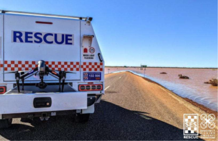
On 23 January 2022 the Stuart Highway, a major transport corridor through the centre of South Australia was severed at Glendambo. Glendambo is a small town 600km north of Adelaide, consisting of two roadhouses, a hotel-motel and caravan park. Glendambo is the last source of fuel before the 254km journey north to Coober Pedy.
The Highway was submerged beneath more than 450mm of water and the road condition was unknown for over 8 days. Road freight from north to south of Australia ceased. Concurrently, significant railway line damage was reported, halting rail transport east-west across the country. Repairs to railway lines were estimated to take weeks and so the timely restoration of the road corridor was of critical importance. Movement of critical food and supplies to Coober Pedy and the Northern Territory ceased. Travellers were isolated, unable to cross the water to Glendambo and unable to complete the 254km drive back to Coober Pedy without access to fuel.
SASES activated the SES State Control Centre and Regional Coordination Centres on Friday 21 January in anticipation of the forecast severe weather event. Heavy and persistent rain over the next few days caused the significant infrastructure damage.
A Major Emergency Declaration was signed by the State Coordinator on 28 January, from which time SES personnel were supplemented with Liaison Officers from several agencies and Functional Support Groups. This declaration remained in place until 8 February.
The National Heavy Vehicle Regulator investigated alternative Type II Network Routes (for B-triple trucks) through Queensland. However, this new route became compromised by floodwaters on the Queensland/ Northern Territory border. Additional road routes were investigated through Woomera Department of Defence property but not feasible due to floodwater.
Understanding the volume and footprint of water covering the Stuart Highway was of critical importance in order to plan to resolve the situation. SES Swiftwater Rescue Technicians were passengers in fixed wing flights (Air Observer missions) and captured photos of the affected area. The photographs provided an overview of the area of impact and revealed that the depth of the water meant relying on evaporation alone was not an option. Further intelligence was needed to inform an engineering solution; this was difficult to obtain from high elevation, oblique angle images. The Air Observer photos provided a static reference of the water level and topographic challenges of the surrounding terrain.
The following is a paper presented at AFAC Conference 2022 by members of the South Australia State Emergency Service.
Mr Jayme Moreland – Chief Remote Pilot & Capability Coordinator
Dr Sara Pulford – Principal Officer, Information Systems

The images lacked detail and depth from a distance and photos taken closer did not provide an appreciation of the whole incident scene. In an attempt to obtain up-to-date imagery of the flooded Stuart Highway and other isolated roads, satellite imagery was utilised. The Copernicus Satellite Emergency Management Service was activated to provide high level imagery of multiple flooded regional roads across South Australia. Unfortunately, the image quality was hampered by cloud cover.
Remotely Piloted Aircraft (RPAs, commonly known as drones) were deployed to Glendambo to provide targeted, detailed, low altitude imagery. Four RPAs of different size and capability and SES’ Chief Remote Pilot were deployed via road from Adelaide to Glendambo.
The objective was to conduct Remotely Piloted Aircraft operations in order to capture imagery to produce orthomosaic and panoramic products for briefings, situational awareness and planning. Videos and photos were also used for public awareness and social media distribution.
Four RPAs were utilised for this mission:
DJI Inspire 2
DJI Phantom 4 Pro+
DJI Mavic 2 Enterprise (Dual) – vision camera and thermal camera
DJI Mavic Mini
The RPAs are of varying size and specification and allow the capturing of imagery in a variety of environments and conditions.

